Today, October 21st, 2020, is the day of the Magallanes y Antártica Chilena region, which commemorates 500 years since the discovery and crossing of the, at the time, called “Todos los Santos” canal. This discovery and expedition were led by the Portuguese explorer and navigator Ferdinand Magellan, also known as Hernando de Magallanes. Nowadays, this strait is known by his name. This event was one of the most important for the area, which set the starting point of the intense history of this place in the last centuries and defined it under different social and cultural aspects. From this milestone onwards, we will talk about a historical, and still pending, disagreement between Chile and Argentina that is relevant to the region and the entire country.
From the north to south of Chile, there are more than 24,000 glaciers, which increase in size and quantity as we approach the Zona Austral. Our continental ice fields are divided into two parts, one larger than the other; the first one corresponds to the Campos de Hielo Norte [Northern Ice Field], where the San Valentín hill that feeds the Exploradores glacier, the San Rafael lake, the Exploradores and Leones valleys, as well as the Steffen glacier stand out. The second and most extensive is the Campos de Hielo Sur [Southern Ice Fields], where some glaciers and lakes branch off to the Argentinian side through the Santa Cruz province. These vast frozen fields ranked third worldwide after Antarctica and Greenland in terms of ice quantity and size. Despite its richness and magnitude, today there is an area of about 1,000 km2 that is still not defined between Chile and Argentina, which led to a territorial conflict that has been sought to solve over the years, without reaching conclusive treaties. Today, this is a very important issue for both countries because, more than defining or establishing limits, the emphasis lies on the quantity of the stored fresh water in this millenary ice, which is a vital and scarce resource for human beings and the ecosystems. A real and tangible shortage could bring future conflicts between both countries.
History
On November 27th, 1520, Ferdinand Magellan entered the Pacific Ocean, as he named it, discovering the Strait of Magellan that connects the Pacific Ocean with the Atlantic Ocean, which changed the course of navigation in the world. Due to this geographical event, the Magallanes y la Antártica Chilena region was founded.
The first discoveries of the Campos de Hielo are ascribed to the indigenous people who lived in the surrounding areas and traveled fjords and southern canals in handmade canoes. Through generations, it was said that these steep ice-covered mountains were inhabited by a mythological being, who they called Mwono.
In 1557, García Hurtado de Mendoza, who was the Governor of Chile, sent a ship named San Luis. This crew was one of the first to admire millenary ice. However, with the arrival of the colonizers, the Campos Patagónicos de Hielo Sur (CPHS) were opened to the Western world.
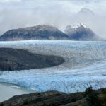
CPHS is the largest ice mass in the southern hemisphere, besides Antarctica. Regarding its morphology, it comprises 49 glaciers, along with hundreds of smaller glaciers in the west and east of the Andes Mountain Range. In the accumulation zone, the ice is joined in a uniform and flat way called a “plateau” with a height of 1,600 meters. There is an area that allows the location of the largest glaciers of the ice fields; to the north of the Murallón hill (near the place of the conflict), the mountainous area becomes wider, which contributes to the formation of larger glaciers.
Regarding the bordering areas, the CPHS covers an area of approximately 175 to 180 km, of which 81 % to 92 % belongs to Chile and the rest to Argentina. It’s quite evident the great wealth that Chile owns when it comes to these virgin areas. Unfortunately, these areas are still poorly studied due to their location and the Patagonian weather, which has hindered the task of scientists and explorers.
Best-known glaciers of the Campos Patagónicos de Hielo Sur

Pio IX glacier, one of the few glaciers that advances worldwide. In 2011, it experienced an advance in its northern side of about 1.2 km. / Photograph taken by Alberto de Agostini in 1945.

Amalia glacier, located inside the Bernardo O’Higgins National Park, has a diameter of about 2.5 km wide and 70 meters high. / © Felipe Espinosa Cancino.

Grey glacier, an iconic glacier located in the Torres del Paine National Park. In recent years, images of huge landslides from its frontal side have gone viral / © Nicolás Vivar.

Lautaro glacier, little known, goes down from the Lautaro volcano, also known as HPS9 glacier, which extends for about 19 km and has a total area of 55 km2. It’s adjacent to the great Pio IX / © Daniel Lagos.

O’Higgins glacier has a total surface area of 828 km2. It has experienced a huge retreat of about 15 km in the last century. This glacier has a homonymous far-reaching glacier lake. / © Patagonia Fotos.

Serrano glacier is located in the Bernardo O’Higgins National Park, in the Magallanes Even though this glacier is not directly adjacent to the ice field, some people consider it part of it / © Catalina Pérez.
Political advances in the Treaty of 1881
1881: In this year, Chile was in the middle of the Pacific War and couldn’t be on two sides fighting a war, so it was vulnerable to losing these territories. The Argentinian authorities at the time exerted such pressure that Chile gave away about 1,264,000 km2 of territory, which today is the entire southern side of Argentina, in the Tratado de Límites de 1881[Boundary Treaty of 1881] between Chile and Argentina.
1888: The idea of defining the border lines is discussed again, where each country hires an expert. Chile hired Diego Barros Arana, and Argentina hired Octavio Burgués, who weren’t able to reach an agreement.
1893: The discussions to solve a pending issue on the Treaty of 1881 are resumed, which stated the following:
The border between Chile and the Republic of Argentina is, from North to South up to the parallel 52 of latitude, the Andes Mountain Range. The boundary line will run along the highest peaks of that mountain range that divide the waters and will pass across the slopes that fall from one side to the other. The experts and the sub-commissions will have this principle as an invariable rule in their procedures. Therefore, it shall be held in perpetuity as property and freehold of the Argentinian Republic, all the lands and water, that is: lakes, lagoons, rivers and parts of rivers, streams, and slopes, which are to the east of the line of the highest peaks of the Andes Mountain Range that separates the water. For Chile, it shall be held as property and freehold all the lands and the water, that is: lakes, lagoons, rivers, and parts of the rivers, streams, and slopes, which are to the west of the highest peaks of the Andes Mountain Range that separates the water.
The problem was that the watershed lines of the Andes Mountain Range didn’t always coincide with the high peaks of this mountain range. Argentina argued that the boundary should be according to an orographic boundary and go through the highest peaks of the Andes. On the other hand, Chile considered that the continental watershed lines should be what clarifies the boundaries. That was the reason they didn’t reach an agreement again.
1902: On May 28th, Chile and Argentina signed several treaties by the name of Tratado de Equivalencia Naval, Paz y Amistad[Treaty of Naval Equivalence, Peace, and Friendship or Pacts of May]. Both States turn to the British crown to intervene in the territorial conflict. King Edward VII appointed an expert named Sir Thomas Hungerford Holdich, a colonel and a judge to reach a sentence. When they arrived at the CPHS, it was determined that the division of the continental water coincided with the highest mountain peaks of the area concerned. However, an expedition conducted by trans-Andean scientists in 1914 invalidates that sentence because during the expedition carried out on the northwestern side of the Viedma Lake it was discovered a mountain range named Mariano Moreno. The British judges didn’t notify this mountain range as it was covered with ice and unnoticed at the time of the sentence.
1941: On April 16th, an agreement is signed in Buenos Aires to establish a commission composed of scientists from both countries to set the boundaries clearly and concisely, but this project wasn’t successful because the Joint Committee alleged not to have the technical potential to develop the appropriate boundaries in the Campos de Hielo Sur.
1943: The government began the studies with help from the United States because it requested the use of aircraft to help glimpse the size of the ice fields from the air.
1990: The most significant advances in this process were made during this decade. In Santiago, the Chilean president Patricio Aylwin and the Argentinian president Carlos Saúl Menem signed an agreement, in which the Comisión Mixta Latinoamericana [Latin American Joint Committee] is in charge of this issue. The Committee relied on the previous treaties to clarify and define 22 of 24 points. Sections A and B of the Campos de Hielo Sur remained pending.
1998: The reelected Argentinian president Menem and the Chilean president Eduardo Frei Montalva sign an agreement that states:
“The parties entrust the Comisión Mixta de Límites Chile-Argentina [Boundaries Joint Committee of Chile and Argentina] to perform a survey to elaborate the chart to scale 1:50,000″ and “This cartographic survey in the above-mentioned scale will be an essential requirement to carry out the demarcation on the area.”

In this way, section A of the ice fields is completely defined in the delimitations that go from Daudet hill to Murallón hill. Section B couldn’t be defined and remains pending to this day. / Reference photo of border lines of Campo de Hielo Patagónico Sur. (February 24, 2018).
Water crisis
Our planet is covered with approximately 70 % water, of which 97 % is salt water and just 3 % is freshwater. Only 0,025 % of the freshwater is drinking water since a large part of it is frozen or belongs to the soil moisture. The global population increases as well as the demand for resources and water. Today, in many parts of the world, this is not a fundamental right. In some places of Chile that have been hit hard by the mining and private water rights companies, water is distributed with cistern trucks due to the severe drought and desertification.
Because of this, it’s essential to reach a political agreement between both States to define the remaining boundaries since the water crisis will affect our country in the near future. In fact, there are already megaprojects to build water roads to supply the northern area; however, this would not solve the real problem. Therefore, protecting these huge freshwater reserves and conserving them promptly is very important for both countries.
Chile and Argentina, neighboring Latin American countries, have never had armed conflicts concerning boundary issues or in any other matter, which is very important to mention, because there were moments of great tension, but that did not trigger any wars. All these treaties exposed in this article highlight the efforts of both countries to achieve mutual agreements peacefully.
The current technologies should help define this territorial “conflict” since the previous treaties didn’t conclude because of the lack of technical and scientific equipment to carry out the investigations of these vast ice fields.
This is very important for our glaciers. The Chilean territory has more than 24,000 glaciers, and most of them are in national reserves or parks; however, there is a portion of about 1,000 km2 that is not under the sovereignty of any of the two countries, which means that it’s unprotected without ensuring its preservation. Protecting this millenary ice is to think about the future since their wealth of water resources is incalculable.
As Fundación Glaciares Chilenos, we seek to educate people interested in our natural heritage of great vital value, so that they are protected and safeguarded by the State. Thus, Argentina and Chile must urgently define section B of the Campos de Hielo Sur as a cooperation strategy to face the approaching water crisis and maintain peace and dialogue, reaching a mutual agreement that achieves a real and true commitment concerning the preservation of our vital resource, the water.
This agreement should be supported by the previous treaties to value the work of many Chilean and Argentinian people as well as authorities, technicians, and scientists who have sought a definitive solution for this place full of glaciers, mountain ranges, and volcanoes, recognizing water as the cornerstone of the ecosystems.
- Casassa Rogazinski, G., & Rivera, A. (2001). Campo de Hielo Patagónico Sur: su historia. In Anales del Instituto de la Patagonia. [Article: Southern Patagonia Icefield: Its History] Link
- Campo de Hielo Sur: Una fuente para la cooperación, Sebastián Peredo. [Master tesis: Southern Ice Field: A source for cooperation] Link
- Solo el 0,025% del agua de la tierra es potable, Nueva Tribuna. [Article: Only 0.025 % of the Earth’s water is drinkable] Link
- Magallanes, Magallanes: 500 años de historia, El Pingüino, 2020. [Editorial: Magallanes, Mallaganes: 500 years of history] Link
-
Aerial view of the area without defined borders near the Murallón hill, Patagonia. / © NASA. Location link
Agreement UMAG/CIGA-FGCh:
This article was published under the collaboration agreement between Centro de Investigación GAIA Antártica de la Universidad de Magallanes (CIGA UMAG) [Research Center GAIA Antártica of the University of Magallanes] and Fundación Glaciares Chilenos.